> ## Documentation Index
> Fetch the complete documentation index at: https://docs.altnautica.com/llms.txt
> Use this file to discover all available pages before exploring further.
# Mission Planning
> Plan waypoint missions with terrain following, validation, and batch editing.
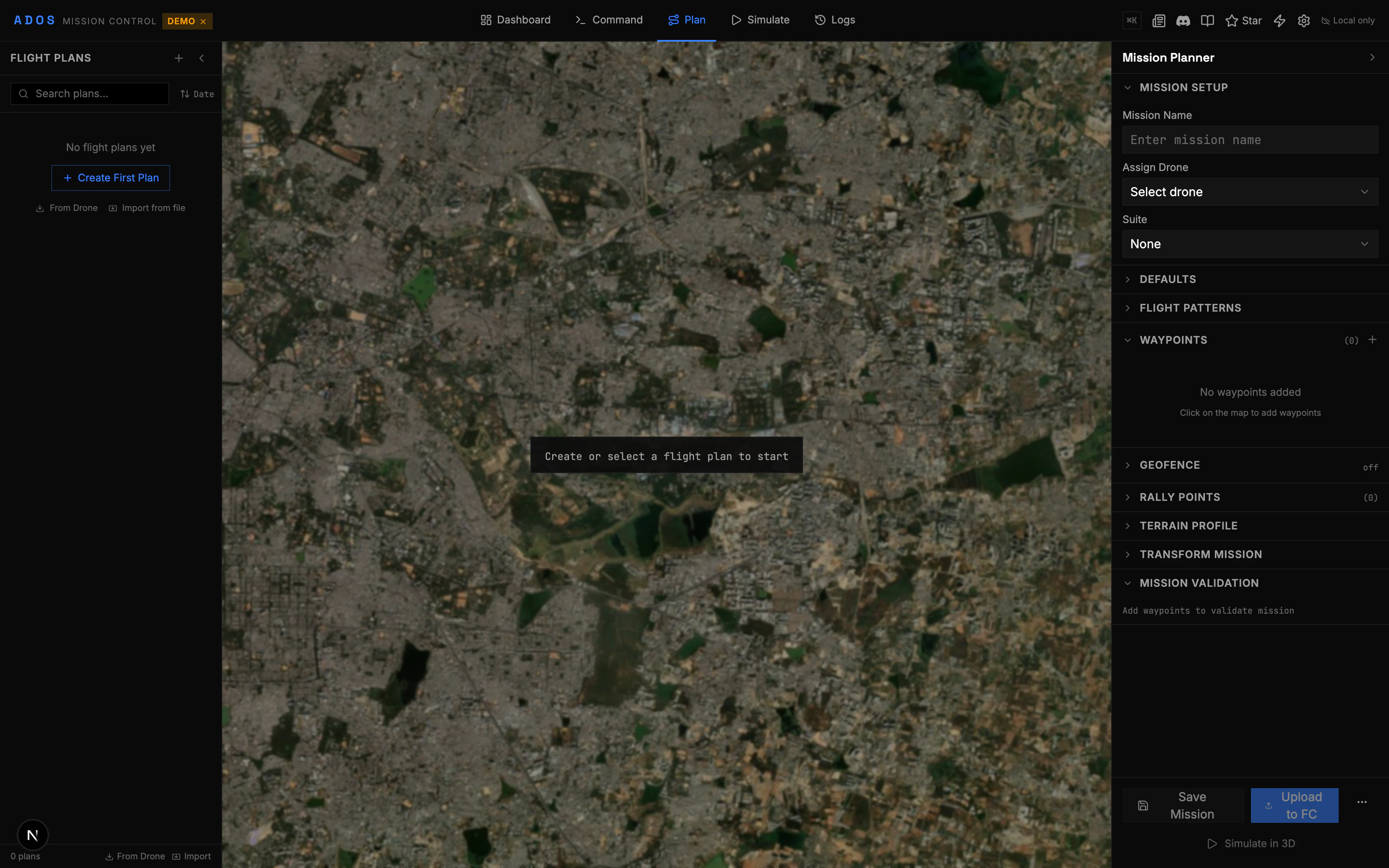
The Plan tab is a full mission planner built on a Leaflet map. Create waypoint missions, add commands, configure terrain following, and validate everything before uploading to your flight controller.
 ## Creating a Mission
Click "Plan" in the top navigation bar. The map fills the screen with a toolbar on the left and a mission editor on the right.
Click on the map to place waypoints. Each click adds a numbered waypoint at that location. Waypoints are connected by lines showing the flight path.
Click a waypoint marker to select it. The right panel shows its properties: latitude, longitude, altitude, speed, delay, and command type.
Choose between relative (above home), absolute (above sea level), or terrain-following altitude for each waypoint.
Click the validate button. The validation engine checks for common issues before upload.
Send the mission to the flight controller. The upload progress is shown in real time.
## Map Toolbar
The left-side toolbar provides drawing and editing tools:
| Tool | Function |
| -------- | ------------------------------------------- |
| Waypoint | Click to place individual waypoints |
| Polygon | Draw a boundary for pattern generators |
| Circle | Draw a circular area for orbit or geofence |
| Measure | Measure distance and bearing between points |
| Select | Click to select and move existing waypoints |
Right-click the map to open a context menu with additional options: insert waypoint here, set home position, center map, and more.
## Mission Editor
The right panel shows the mission as an ordered list of waypoints and commands:
* **Reorder** waypoints by dragging
* **Delete** individual waypoints
* **Edit** properties inline (altitude, speed, delay, command type)
* **Add commands** between waypoints (DO\_SET\_SERVO, DO\_CHANGE\_SPEED, DO\_SET\_CAM\_TRIGG\_DIST, etc.)
### Supported Commands
Mission Control supports the standard MAVLink mission item commands:
| Command | Description |
| ------------------------- | ------------------------------------ |
| NAV\_WAYPOINT | Fly to a waypoint |
| NAV\_LOITER\_UNLIM | Loiter at a position indefinitely |
| NAV\_LOITER\_TURNS | Loiter for a set number of turns |
| NAV\_LOITER\_TIME | Loiter for a set duration |
| NAV\_RETURN\_TO\_LAUNCH | Return to home |
| NAV\_LAND | Land at a position |
| NAV\_TAKEOFF | Takeoff to altitude |
| NAV\_SPLINE\_WAYPOINT | Smooth spline path through waypoint |
| DO\_SET\_SPEED | Change flight speed |
| DO\_CHANGE\_SPEED | Change speed mid-mission |
| DO\_SET\_CAM\_TRIGG\_DIST | Camera trigger by distance |
| DO\_SET\_SERVO | Set a servo output |
| DO\_JUMP | Jump to a waypoint (looping) |
| DO\_SET\_ROI | Point camera at a region of interest |
| DO\_VTOL\_TRANSITION | Switch between VTOL and fixed-wing |
## Terrain Following
Enable terrain following to maintain a consistent altitude above ground level (AGL), even over hilly terrain.
**How it works:**
1. The planner fetches elevation data from the Open Elevation API for each waypoint.
2. Waypoint altitudes are adjusted so the drone maintains your specified AGL at every point.
3. The terrain profile chart at the bottom shows ground elevation vs. flight altitude.
Terrain data is cached with an LRU cache keyed by rounded coordinates (4 decimal places). When you plan surveys in the same area, subsequent requests use the cache.
The Terrain Profile Chart shows:
* Ground elevation line
* Flight path altitude line
* AGL clearance at each waypoint
* Warnings where clearance is below a threshold
## Batch Editor
The batch editor lets you modify multiple waypoints at once:
* **Set altitude** for all selected waypoints
* **Set speed** for all selected waypoints
* **Adjust altitude** by a relative offset (e.g., raise all by 10m)
* **Apply terrain following** to a selection
Select multiple waypoints by holding Shift and clicking, or by drawing a selection rectangle. Then open the batch editor to apply changes.
## Mission Transforms
Move, rotate, or scale an entire mission without editing individual waypoints:
* **Move:** Drag the mission to a new location. All waypoints shift by the same offset.
* **Rotate:** Spin the mission around its center point. Enter a rotation angle in degrees.
* **Scale:** Grow or shrink the mission. Enter a scale factor.
These are pure geometry operations that preserve the relative positions and altitudes of all waypoints.
## Mission Stats Bar
The bottom bar shows live statistics about your mission:
* Total distance
* Estimated flight time (based on configured speed)
* Number of waypoints
* Altitude range (min and max)
* Estimated battery usage
## Validation
Before uploading, the validation engine checks your mission for issues:
* No waypoints in mission
* Waypoints outside geofence (if one is set)
* Altitude below minimum safe altitude
* Missing takeoff command at the start
* Invalid command parameters
* Very high altitude waypoints
* Long distances between waypoints
* Speed changes that may exceed airframe limits
* Mission exceeds estimated battery capacity
* No RTL or Land command at the end
## Download and Upload
| Action | Description |
| -------------------- | -------------------------------------------------------------------------------- |
| **Upload to FC** | Send the mission to the connected flight controller via MAVLink MISSION protocol |
| **Download from FC** | Read the current mission stored on the flight controller |
| **Save to file** | Export to `.waypoints`, `.plan`, KML, KMZ, or CSV format |
| **Load from file** | Import a mission from any supported file format |
| **Save to library** | Store the mission in the plan library for later reuse |
See [File Formats](/mission-control/file-formats) for details on each format.
## Keyboard Shortcuts
| Shortcut | Action |
| ---------------------- | ------------------------ |
| `Delete` / `Backspace` | Remove selected waypoint |
| `Ctrl+Z` | Undo last action |
| `Ctrl+Shift+Z` | Redo |
| `Ctrl+A` | Select all waypoints |
| `Escape` | Deselect all |
## Creating a Mission
Click "Plan" in the top navigation bar. The map fills the screen with a toolbar on the left and a mission editor on the right.
Click on the map to place waypoints. Each click adds a numbered waypoint at that location. Waypoints are connected by lines showing the flight path.
Click a waypoint marker to select it. The right panel shows its properties: latitude, longitude, altitude, speed, delay, and command type.
Choose between relative (above home), absolute (above sea level), or terrain-following altitude for each waypoint.
Click the validate button. The validation engine checks for common issues before upload.
Send the mission to the flight controller. The upload progress is shown in real time.
## Map Toolbar
The left-side toolbar provides drawing and editing tools:
| Tool | Function |
| -------- | ------------------------------------------- |
| Waypoint | Click to place individual waypoints |
| Polygon | Draw a boundary for pattern generators |
| Circle | Draw a circular area for orbit or geofence |
| Measure | Measure distance and bearing between points |
| Select | Click to select and move existing waypoints |
Right-click the map to open a context menu with additional options: insert waypoint here, set home position, center map, and more.
## Mission Editor
The right panel shows the mission as an ordered list of waypoints and commands:
* **Reorder** waypoints by dragging
* **Delete** individual waypoints
* **Edit** properties inline (altitude, speed, delay, command type)
* **Add commands** between waypoints (DO\_SET\_SERVO, DO\_CHANGE\_SPEED, DO\_SET\_CAM\_TRIGG\_DIST, etc.)
### Supported Commands
Mission Control supports the standard MAVLink mission item commands:
| Command | Description |
| ------------------------- | ------------------------------------ |
| NAV\_WAYPOINT | Fly to a waypoint |
| NAV\_LOITER\_UNLIM | Loiter at a position indefinitely |
| NAV\_LOITER\_TURNS | Loiter for a set number of turns |
| NAV\_LOITER\_TIME | Loiter for a set duration |
| NAV\_RETURN\_TO\_LAUNCH | Return to home |
| NAV\_LAND | Land at a position |
| NAV\_TAKEOFF | Takeoff to altitude |
| NAV\_SPLINE\_WAYPOINT | Smooth spline path through waypoint |
| DO\_SET\_SPEED | Change flight speed |
| DO\_CHANGE\_SPEED | Change speed mid-mission |
| DO\_SET\_CAM\_TRIGG\_DIST | Camera trigger by distance |
| DO\_SET\_SERVO | Set a servo output |
| DO\_JUMP | Jump to a waypoint (looping) |
| DO\_SET\_ROI | Point camera at a region of interest |
| DO\_VTOL\_TRANSITION | Switch between VTOL and fixed-wing |
## Terrain Following
Enable terrain following to maintain a consistent altitude above ground level (AGL), even over hilly terrain.
**How it works:**
1. The planner fetches elevation data from the Open Elevation API for each waypoint.
2. Waypoint altitudes are adjusted so the drone maintains your specified AGL at every point.
3. The terrain profile chart at the bottom shows ground elevation vs. flight altitude.
Terrain data is cached with an LRU cache keyed by rounded coordinates (4 decimal places). When you plan surveys in the same area, subsequent requests use the cache.
The Terrain Profile Chart shows:
* Ground elevation line
* Flight path altitude line
* AGL clearance at each waypoint
* Warnings where clearance is below a threshold
## Batch Editor
The batch editor lets you modify multiple waypoints at once:
* **Set altitude** for all selected waypoints
* **Set speed** for all selected waypoints
* **Adjust altitude** by a relative offset (e.g., raise all by 10m)
* **Apply terrain following** to a selection
Select multiple waypoints by holding Shift and clicking, or by drawing a selection rectangle. Then open the batch editor to apply changes.
## Mission Transforms
Move, rotate, or scale an entire mission without editing individual waypoints:
* **Move:** Drag the mission to a new location. All waypoints shift by the same offset.
* **Rotate:** Spin the mission around its center point. Enter a rotation angle in degrees.
* **Scale:** Grow or shrink the mission. Enter a scale factor.
These are pure geometry operations that preserve the relative positions and altitudes of all waypoints.
## Mission Stats Bar
The bottom bar shows live statistics about your mission:
* Total distance
* Estimated flight time (based on configured speed)
* Number of waypoints
* Altitude range (min and max)
* Estimated battery usage
## Validation
Before uploading, the validation engine checks your mission for issues:
* No waypoints in mission
* Waypoints outside geofence (if one is set)
* Altitude below minimum safe altitude
* Missing takeoff command at the start
* Invalid command parameters
* Very high altitude waypoints
* Long distances between waypoints
* Speed changes that may exceed airframe limits
* Mission exceeds estimated battery capacity
* No RTL or Land command at the end
## Download and Upload
| Action | Description |
| -------------------- | -------------------------------------------------------------------------------- |
| **Upload to FC** | Send the mission to the connected flight controller via MAVLink MISSION protocol |
| **Download from FC** | Read the current mission stored on the flight controller |
| **Save to file** | Export to `.waypoints`, `.plan`, KML, KMZ, or CSV format |
| **Load from file** | Import a mission from any supported file format |
| **Save to library** | Store the mission in the plan library for later reuse |
See [File Formats](/mission-control/file-formats) for details on each format.
## Keyboard Shortcuts
| Shortcut | Action |
| ---------------------- | ------------------------ |
| `Delete` / `Backspace` | Remove selected waypoint |
| `Ctrl+Z` | Undo last action |
| `Ctrl+Shift+Z` | Redo |
| `Ctrl+A` | Select all waypoints |
| `Escape` | Deselect all |