> ## Documentation Index
> Fetch the complete documentation index at: https://docs.altnautica.com/llms.txt
> Use this file to discover all available pages before exploring further.
# 3D Simulation
> CesiumJS globe with mission replay, flight path visualization, and playback controls.
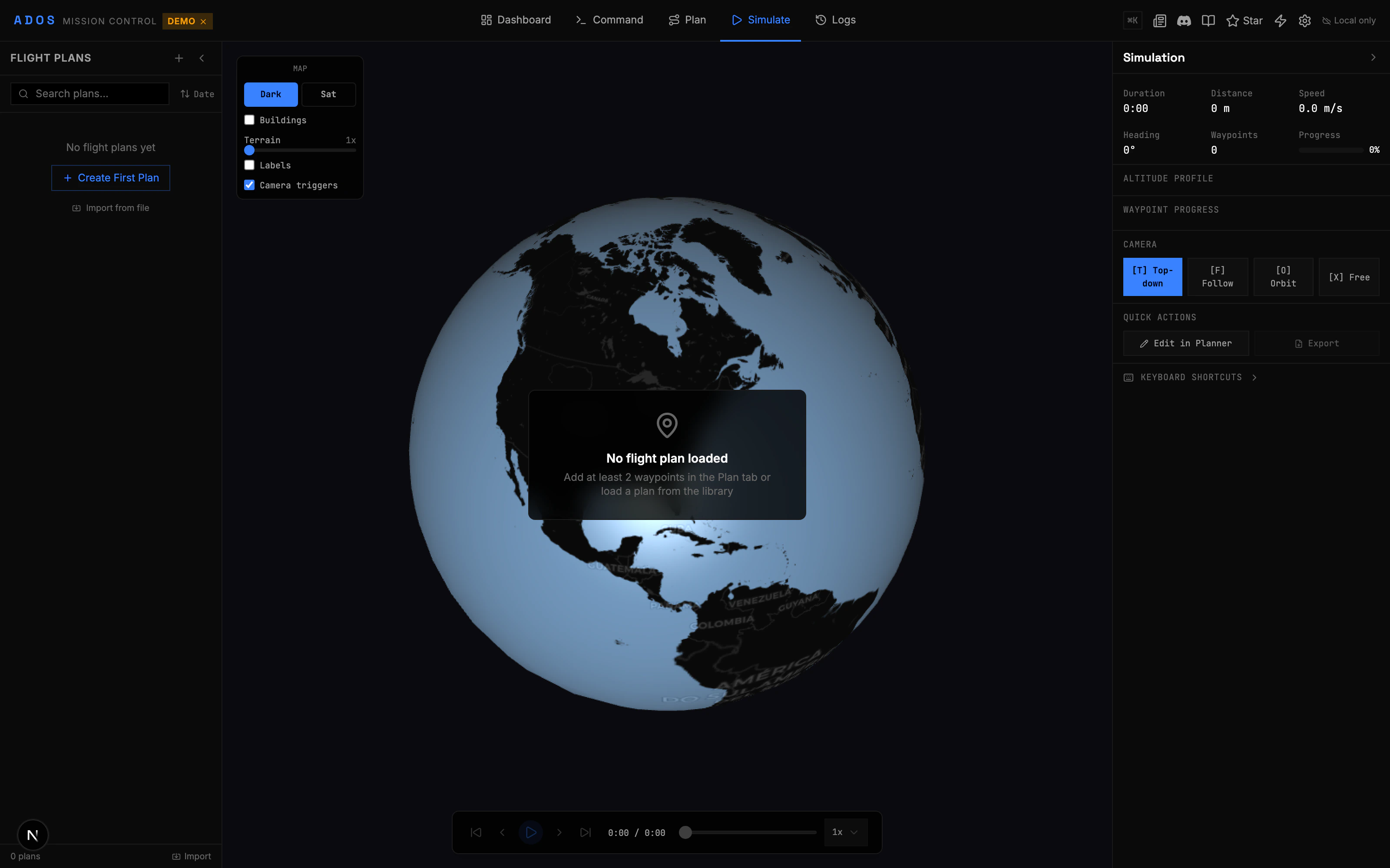
The Simulate tab renders your missions and flight history on a 3D CesiumJS globe. Replay recorded flights, preview planned missions, and inspect the flight path from any angle.
 ## What You Can Visualize
The simulation viewer renders multiple layers on the 3D globe:
| Layer | Description |
| ------------------------- | ----------------------------------------------------------------- |
| **Flight path** | 3D polyline showing the drone's actual or planned route |
| **Drone entity** | An animated drone model that moves along the path during playback |
| **Waypoint markers** | Numbered markers at each mission waypoint position |
| **Camera trigger points** | Markers showing where camera shutter events occur |
| **Geofence volumes** | 3D extruded polygons/cylinders showing geofence boundaries |
| **Rally point markers** | Flag markers at rally point positions |
| **Pattern boundaries** | The source polygon for pattern-generated missions |
| **GCS position** | Your ground station location on the globe |
| **Drone trail** | A fading trail behind the drone during playback |
## Replaying a Flight
Click "Simulate" in the top navigation.
Select a flight from the left panel. This can be a saved mission or a recorded flight log from the History tab.
The playback bar at the bottom controls the replay. Play, pause, scrub the timeline, or adjust playback speed.
Rotate, zoom, and tilt the globe to view the flight from any angle. The camera can follow the drone or be positioned freely.
## Playback Controls
The playback bar provides standard media controls:
| Control | Function |
| ------------------- | --------------------------------------- |
| Play / Pause | Start or stop playback |
| Scrub bar | Drag to jump to any point in the flight |
| Speed selector | 0.5x, 1x, 2x, 4x, 8x playback speed |
| Step forward / back | Advance or rewind by one data frame |
| Reset | Return to the beginning |
## Simulation HUD
During playback, a heads-up display overlay shows real-time data at the current playback position:
* Altitude (AGL and MSL)
* Ground speed
* Heading
* Battery level at that moment
* GPS status
* Distance from home
* Current waypoint (for mission replays)
## Altitude Profile
Below the 3D view, an altitude profile chart shows:
* Flight altitude over time or distance
* Ground elevation (terrain line)
* AGL clearance at each point
* Waypoint altitude targets vs actual altitude
This is useful for verifying terrain following and checking that the drone maintained safe clearance.
## Mission Preview
Before flying, you can preview a planned mission in 3D:
1. Plan a mission in the Plan tab.
2. Switch to the Simulate tab.
3. The planned mission renders as waypoints connected by path lines.
4. Play the preview to see an animated drone fly the planned route.
This helps you visualize the mission in 3D before uploading to the FC, especially over hilly terrain where 2D map views can be misleading.
## Map Controls Panel
The controls panel on the side lets you toggle visualization layers:
* Show/hide flight path
* Show/hide waypoint markers
* Show/hide camera triggers
* Show/hide geofence volumes
* Show/hide rally points
* Toggle terrain imagery (satellite, terrain, or both)
* Toggle 3D buildings (in supported areas)
## Camera Modes
The CesiumJS viewer supports several camera modes:
| Mode | Description |
| ---------------- | --------------------------------------------------- |
| **Free** | Manually control the camera with mouse/touch |
| **Follow** | Camera follows the drone, looking at it from behind |
| **Overhead** | Top-down view following the drone |
| **First person** | Camera positioned at the drone, looking forward |
## Cesium Token
CesiumJS requires an API token for terrain data and 3D tiles. Set the `NEXT_PUBLIC_CESIUM_TOKEN` environment variable with your Cesium ion token. Without a token, the globe still works but terrain elevation may be flat.
```bash theme={"theme":{"light":"github-light","dark":"github-dark"}}
NEXT_PUBLIC_CESIUM_TOKEN=your_cesium_ion_token_here
```
Get a free token at [cesium.com/ion](https://cesium.com/ion).
## History Integration
The [History](/mission-control/settings) tab records flight data. From the History tab, you can:
1. Select a recorded flight.
2. Click "Open in Simulation" to load it in the 3D viewer.
3. Replay the flight with full telemetry overlay.
History detail pages also include their own analysis tools: statistics panels, correlation charts, and vibration spectrograms.
## Performance Notes
CesiumJS renders a full 3D globe with terrain and imagery. For best performance:
* Use a dedicated GPU or integrated graphics with WebGL 2 support
* Close other GPU-heavy browser tabs
* Reduce the browser window size if frame rate drops
* On low-end machines, disable 3D buildings and use simplified terrain
## What You Can Visualize
The simulation viewer renders multiple layers on the 3D globe:
| Layer | Description |
| ------------------------- | ----------------------------------------------------------------- |
| **Flight path** | 3D polyline showing the drone's actual or planned route |
| **Drone entity** | An animated drone model that moves along the path during playback |
| **Waypoint markers** | Numbered markers at each mission waypoint position |
| **Camera trigger points** | Markers showing where camera shutter events occur |
| **Geofence volumes** | 3D extruded polygons/cylinders showing geofence boundaries |
| **Rally point markers** | Flag markers at rally point positions |
| **Pattern boundaries** | The source polygon for pattern-generated missions |
| **GCS position** | Your ground station location on the globe |
| **Drone trail** | A fading trail behind the drone during playback |
## Replaying a Flight
Click "Simulate" in the top navigation.
Select a flight from the left panel. This can be a saved mission or a recorded flight log from the History tab.
The playback bar at the bottom controls the replay. Play, pause, scrub the timeline, or adjust playback speed.
Rotate, zoom, and tilt the globe to view the flight from any angle. The camera can follow the drone or be positioned freely.
## Playback Controls
The playback bar provides standard media controls:
| Control | Function |
| ------------------- | --------------------------------------- |
| Play / Pause | Start or stop playback |
| Scrub bar | Drag to jump to any point in the flight |
| Speed selector | 0.5x, 1x, 2x, 4x, 8x playback speed |
| Step forward / back | Advance or rewind by one data frame |
| Reset | Return to the beginning |
## Simulation HUD
During playback, a heads-up display overlay shows real-time data at the current playback position:
* Altitude (AGL and MSL)
* Ground speed
* Heading
* Battery level at that moment
* GPS status
* Distance from home
* Current waypoint (for mission replays)
## Altitude Profile
Below the 3D view, an altitude profile chart shows:
* Flight altitude over time or distance
* Ground elevation (terrain line)
* AGL clearance at each point
* Waypoint altitude targets vs actual altitude
This is useful for verifying terrain following and checking that the drone maintained safe clearance.
## Mission Preview
Before flying, you can preview a planned mission in 3D:
1. Plan a mission in the Plan tab.
2. Switch to the Simulate tab.
3. The planned mission renders as waypoints connected by path lines.
4. Play the preview to see an animated drone fly the planned route.
This helps you visualize the mission in 3D before uploading to the FC, especially over hilly terrain where 2D map views can be misleading.
## Map Controls Panel
The controls panel on the side lets you toggle visualization layers:
* Show/hide flight path
* Show/hide waypoint markers
* Show/hide camera triggers
* Show/hide geofence volumes
* Show/hide rally points
* Toggle terrain imagery (satellite, terrain, or both)
* Toggle 3D buildings (in supported areas)
## Camera Modes
The CesiumJS viewer supports several camera modes:
| Mode | Description |
| ---------------- | --------------------------------------------------- |
| **Free** | Manually control the camera with mouse/touch |
| **Follow** | Camera follows the drone, looking at it from behind |
| **Overhead** | Top-down view following the drone |
| **First person** | Camera positioned at the drone, looking forward |
## Cesium Token
CesiumJS requires an API token for terrain data and 3D tiles. Set the `NEXT_PUBLIC_CESIUM_TOKEN` environment variable with your Cesium ion token. Without a token, the globe still works but terrain elevation may be flat.
```bash theme={"theme":{"light":"github-light","dark":"github-dark"}}
NEXT_PUBLIC_CESIUM_TOKEN=your_cesium_ion_token_here
```
Get a free token at [cesium.com/ion](https://cesium.com/ion).
## History Integration
The [History](/mission-control/settings) tab records flight data. From the History tab, you can:
1. Select a recorded flight.
2. Click "Open in Simulation" to load it in the 3D viewer.
3. Replay the flight with full telemetry overlay.
History detail pages also include their own analysis tools: statistics panels, correlation charts, and vibration spectrograms.
## Performance Notes
CesiumJS renders a full 3D globe with terrain and imagery. For best performance:
* Use a dedicated GPU or integrated graphics with WebGL 2 support
* Close other GPU-heavy browser tabs
* Reduce the browser window size if frame rate drops
* On low-end machines, disable 3D buildings and use simplified terrain